Paul Revere freely borrowed designs for his engravings from the visual archive of his time. On the right you will find “A South East View of the Great Town of Boston in New England in America”
(Pub. 1743 Drawing by William Burgis- Printed and Sold by William Price, Cornhill). Like most self-promotional literature, the “South East View” offers important clues to Boston’s self-understanding. The long caption of the “View” begins in these glowing terms: “Boston, the Capital of new England and Mistress of North America, is pleasantly situated upon a Peninsula above 6 miles in compass…. It stands at the bottom of a large bay, which (by being defended from the Ocean by a great number of delightful islands) may be reckoned one of the safest and most commodious harbors in the known world.”
The most casual reader of this print will discern the salient features of Boston’s self-image as they were developed in the first century of settlement. First, Boston is proudly British. Several large ships of war occupy the foreground of the print with two of them (somewhat implausibly) discharging their cannons. At least three forts are visible—Fort George (on Bird island), Fort Charles, and a new battery on Boston peninsula around “the Mole.” Forts and ships are all flying the Union Jack. Even after the revolutionary agitation begins, Boston, as “the capital of new England,” sustains its strong orientation toward England. Secondly, Boston is a great place of trade. The large harbor depicted in this print is alive with ships and boats in motion, the Boston peninsula is edged with wharfs and docks, and the caption description calls attention to “Long Wharfe, running 2600 feet into the harbor, and having a very handsome row of store houses on the north side of it.” Finally, Boston is a place of religion and public life. This panorama of Boston shows, and carefully labels, the twenty odd spires of Boston’s meeting houses where the inhabitants gather to worship and govern.
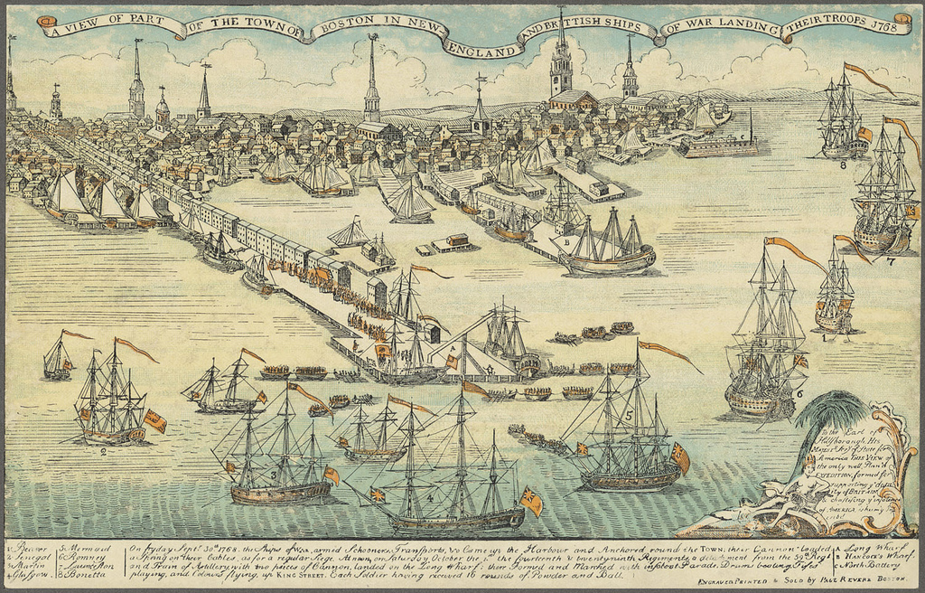
In the weeks after the "Boston Massacre" Paul Review zoomed in to use most of the right portion of the Burgis/Price "View" to represent the day nearly 18th months before the Boston Massacre when "British Ships of War [were] landing their Troops." Athough the print is colored a tranquil blue, now ships of war, with prominant red flags and streamers, are arrayed in a semi-circle around Long Wharf to support with their cannon the investment of the town by British redcoats (here faded to orange).
For a large, high resolution of each view, click to open in a separate browser window.
![Protocols of Liberty: Communication, Innovation, and teh American Revolution [Book Banner from Title Page Image]](Images/William_Warner/Protocols_of_Liberty_Illustrations/Protocols of Liberty - Title Banner.png)